Blue Mountains Climbing guidebooks — updates and corrections page
 This page is for important updates or corrections to the Blue Mountains Climbing guidebooks. The 2019 edition is the latest.
If you are find any CORRECTIONS or anything that needs updating for the next edition of the guidebook, or if you have done any NEW ROUTES that you’d like properly recorded, then please email. Many thanks in advance for your input.
Big Top Camping.
Camping at Big Top is now NOT PERMITTED.
Perry’s Lookdown Camping.
The Perry’s Lookdown campsite near Blackheath is now PERMANENTLY CLOSED.
Gateway & Fort Rock – access change – IMPORTANT!
Access has changed to these areas (May 2020) as the Christian School has stopped access to the general public across their land. No entry signage and cameras have been installed. Do not enter their land day, night or on weekends without direct permission from school. All crags are now accessed either from Burton Street (same carpark as Celebrity), Thirroul Street (via a new track that follows the edge of the private land) or a longish walk from Bundara Street.
GATEWAY:
Park at end of Thirroul Ave. Follow new vague track marked with pink tape leading west from end of road (do not enter school ground). This track goes slowly downhill & west for 200m then swings south (crosses a major track leading downhill). Continue contouring around to a second major track leading downhill (pink tape ends here). Walk down this track for 130m to hit a T-junction. Don’t go right or left – but continue straight ahead on vague trail following rock cairns downhill for 180m – scramble down mini slab then turn left and follow cliffline to mega cave.
It is also possible to walk in from Burton Rd carpark (Celebrity Crag) and walk south – it’s longer but easier to navigate.
FORT ROCK:
There are a couple of ways of accessing this crag.
Option A – park at Bundarra Street. Walk 400m down track to creek crossing, over this and up the hill on the other side (ignoring side track to Centennial Glen) for 350m until you reach Fort Rock lookout (marked on Google Maps). Walk downhill on continuation of track for 200m – and try and spot a small rock cairn/ climbers track on left side. Follow this down for 80m and it arrives directly under orange face with bolts. Scramble up onto small ledge to belay from.
Option B – park at end of Thirroul Ave. Follow new vague track marked with pink tape leading west from end of road (do not enter school ground). This track goes slowly downhill & west for 200m then swings south (crosses a major track leading downhill). Continue contouring around to a second major track leading downhill (pink tape ends here). Walk down this track for 130m to hit a T-junction. Turn left and walk 300m and try and spot a small rock cairn/ climbers track on right side. Follow this down for 80m and it arrives directly under orange face with bolts. Scramble up onto small ledge to belay from.
Kangaroo Corner
We have left this cliff out of the 2019 Edition of the guidebook; the details are in the 2015 Edition. Route details are largely unchanged however the area was badly affected by the 2019/2020 bushfires. Furthermore, access for this cliff is through private property and the landowner, a climber, has commenced building a house on his land. Therefore, privacy, security and safety are some issues. The owner welcomes climbers however, so for access call Matthew on 0407 779 904 beforehand.
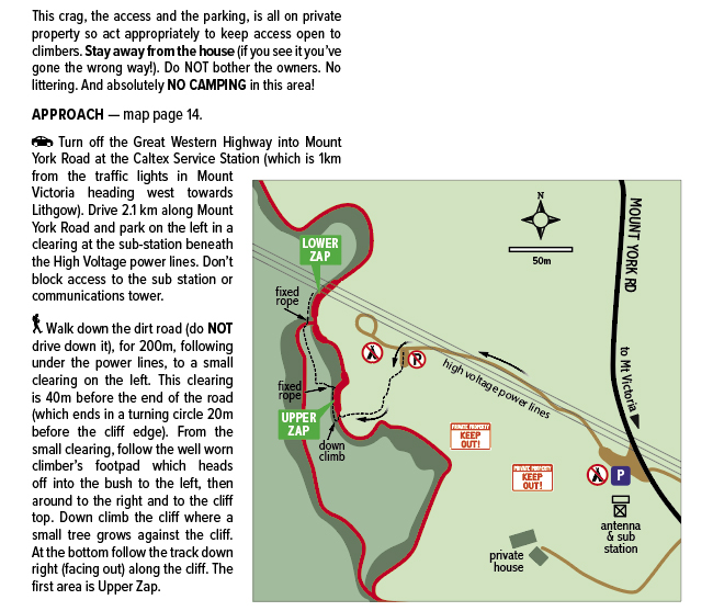
Zap Crag
This crag is entirely on private land and access is through that private land. The landowner is clearly unhappy with the behavior of climbers; camping on the land, driving down the track, walking close to the house…. And so at the landowners instance we have removed the area from the 2019 Edition of the guidebook. Ironically, as of May 2021 the approach description on “TheCrag” website is STILL wrong, and it has no access map showing the approach, both factors possibly contributing to the problem. The only correct information available, that we know of, is in our Best of the Blue guidebook as described and shown here:
2015 Edition Corrections
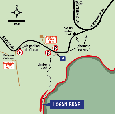
Logan Brae access – IMPORTANT!
Information in the 2019 Edition is correct. If you have the 2015 or earlier edition, please note: The access is through private property and the situation is delicate. Privacy, environmental impact, safety and the parking situation are of concern. As the climbers parking area has become busier the area has started to look more public, resulting in some serious annoyances for the land owners, including someone dumping asbestos here. Remember, the land owners are not inviting you onto their land; if you enter take full personal responsibility for yourself and your actions (and any accidents). The following guidelines have been formulated in conjunction with the Sydney Rock Climbing club, please strictly abide by them:
- Stay on the track, no shortcuts.
- Do not enter any other part of the property.
- Do not damage vegetation. Respect regeneration.
- No dogs. No littering. No fires. No cairns.
- No camping. No overnight parking.
PARKING: From Blackheath drive out on Shipley Road (past the Centennial Glen turnoff) and out onto Shipley Plateau. 4.5km from the Blackheath traffic lights there is a fork in the road, now stay left (signed to Hargraves Lookout) and drive 220m up the hill and park at a small pull off at the second power pole on the left.
- Strictly, no more than four (4) cars are to park here.
- DO NOT park anywhere further up the hill!
- And DO NOT park anywhere on the right (northern) side of the road!
If this space is full, then park at the pull off 80m back down the hill, or somewhere else further back down the road towards Blackheath. Consider car-pooling. If we observe these guidelines, then this access might remain usable for longer. Educate your mates.
Other 2015 Edition corrections:
Page 242. Zap Crag, Approach section: Should say “Drive approximately 2.1km along Mt York Road” (not 4km). Also, walk down the dirt road for 200m (not 400m) until you reach a small clearing on the left. If you see the landowners house you’ve gone the wrong way, go back, do not disturb them.
Page 306 Dalpura Head. I Scream and Grapple Sky is a mixed gear route, not entirely sport. You need small to medium cams for the belay and the start of Pitch 1.
Page 321 Pierces Pass. My Kind of Bliss is trad not sport.
2010 & 2011 Edition Corrections
Looking for updates and corrections to the 2010 Edition Blue Mountains Climbing or the 2011 Edition Selected Sport Crags guidebook? Well, we no longer support those, please update your hardware… (or you could try here).
Bolting Guide
Thinking of placing bolts in the Blue Mountains? The rock here is unusual and normal bolting methods do NOT work properly. To understand the issues better please download and read this –> SOFT ROCK BOLTING GUIDE V7 before proceeding. Obviously it’s an important safety issue and one many local climbers feel very strongly about, so it’s important to get it right. Many thanks to Steve Hawkshaw and Mike Law for all their work on this.